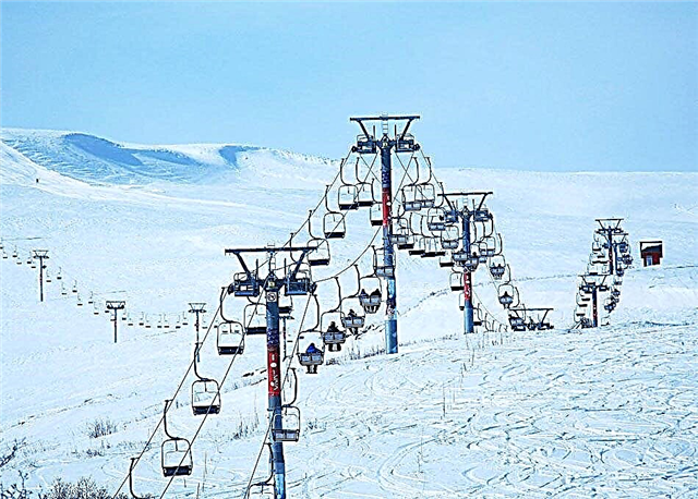
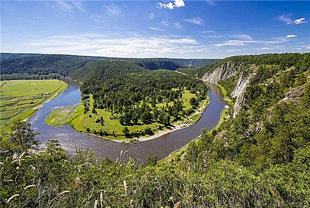
Bashkortostan has ideal conditions for water tourism. Since early spring, numerous fans of outdoor activities flock here to conquer the water element. The most popular routes are laid along the rivers Nugush, Belaya, Ai, Lemeza, Yuryuzan, Zilim. Some of them have a pronounced mountain character, a strong current, and many dangerous obstacles.
Such rivers are of interest to experienced extreme sportsmen. But there are also a large number of routes available to beginners and even tourists with children. Rafting on calm rivers involves leisurely contemplation of coastal landscapes, visiting grottoes, caves and other natural attractions. Excellent fishing will be a pleasant bonus to the trip - after all, all the rivers of Bashkiria are famous for their abundance of fish.
List of the longest rivers in Bashkiria
Ural
Belongs to Bashkortostan only upstream. It starts on the slope of the Uraltau ridge, at the foot of the Kruglaya Sopka mountain. Then it flows through the Chelyabinsk, Orenburg regions, through the territory of Kazakhstan - to the Caspian Sea. In the upper section, the Ural flows in a narrow valley surrounded by mountains, which becomes wider as we move south. A reservoir has been created near the village of Iltebanovo.
The length of the river is 2534 km., In Bashkiria - 165 km.

White (Agidel)
It begins on the territory of the Uchalinsky district, near the Avalyak ridge. It crosses Bashkortostan and flows into the Nizhnekamsk reservoir on the territory of Tatarstan. It is the longest river in the republic. Its name is associated with lime rocks dissolved in water. An important waterway. 2 reservoirs have been built. There are 3 nature reserves in the river basin. In the upper reaches, boating and rafting are popular. The middle and lower reaches are attractive for anglers.
The length of the river is 1430 km.

Ufa
Crosses 2 regions - Chelyabinsk and Sverdlovsk, Bashkortostan. The beginning is the Ufa Lake. It flows into the Belaya River. The river is navigable. The Pavlovsk hydroelectric power station was built on it, as well as a reservoir - one of the most favorite recreation places for local residents. The Ufa basin is located in the protected area of the South Ural Reserve. The river is very popular among fishermen and tourists who make rafting in kayaks.
The length of the river is 918 km, in Bashkiria - 390 km.

Sakmara
Crosses Bashkortostan and Orenburg region. It begins at the Uraltau ridge. It flows into the Urals. A popular object among water tourists, as the current near the river is fast almost throughout the entire length. The most attractive areas for rafting are in the mountainous upper reaches of the river. Dangerous rapids - Yamantash, Barakal. Coastal landscapes are mesmerizing - picturesque gorges, rocks, caves, oak groves, coniferous forests.
The length of the river is 760 km., In Bashkiria - 348 km.

Ik
It starts on the territory of the Belebeevsky district, in the vicinity of the village of Ik-Vershina. It flows through the territory of Bashkortostan and Tatarstan. It flows into the Nizhnekamsk reservoir. Dams have been built in the river basin, and large oil fields are being developed. A nature reserve for the protection of the Red Book marmot was created near the village of Bizhbulyak. The river is rich in fish, grayling and trout are caught in the upper reaches. Not suitable for a beach holiday, as it warms up poorly even in summer.
The length of the river is 571 km.

Ay
Starts in the mountains of the Chelyabinsk region. It flows through 4 districts of Bashkortostan. It flows into the Ufa River. It is very popular among water tourists - routes for rafting and parking have been developed. On the slopes of the river valley there are many natural monuments - picturesque cliffs, cliffs, caves, as well as primitive sites. Near the village of Lakly, there is the famous 5-meter Aisky fountain, which has been gushing out of the ground for more than half a century.
The length of the river is 549 km, in Bashkiria - 278 km.

Dema
Starts on the territory of the Fedorovsky district, in the vicinity of the village of Aleshkino. It flows through the Orenburg region, then returns to Bashkortostan again. Dema is famous for its abundance of fish. It is also an attractive object for lovers of calm rafting and water tourism. Routes start from the city of Davlekanovo. The Yumatovo sanatorium is located in the Dema valley - a popular kumys therapy center.
The length of the river is 535 km, in Bashkiria - 420 km.

Yuryuzan
Natural monument. It flows through the territory of Bashkortostan and the Chelyabinsk region. It starts at the Mashak ridge. It is very popular with water tourists - the rafting is quite calm and safe. The famous Yangantau sanatorium is located on the river. The upper reaches of the Yuryuzan are in the South Ural Reserve. Five picturesque caves along the banks have been declared natural monuments.
The length of the river is 404 km, in Bashkiria - 224 km.

Quick Tanyp
It starts in the marshy territory of the Perm Territory. Then it flows through several districts of Bashkortostan, then flows into the Belaya River. The name of the river does not correspond to the speed of its flow - it is rather slow, on average from 2 to 6 km / h. On many coastal areas, there are very dense thickets of bushes. Such places serve as the beginning or end of the route for the popular rafting here.
The length of the river is 345 km., In Bashkiria - 140 km.

Big Ick
Starts on the Zilair plateau, in the vicinity of the village of Kananikolskoye. It flows through Bashkortostan and the Orenburg region. It flows into the Sakmara River. Drainage area - 7670 km2... In the river valley there is a unique park "Muradymovskoe gorge", famous for the largest concentration of caves in the entire Urals. There are a lot of fish in the river, for which avid fishermen appreciate it. And also it is attractive for fans of sports rafting.
The total length of the river is 341 km.

Inzer
Bolshoi Inzer begins at the Kumardak ridge. After its merger with Maly Inzer, the Inzer River appears near the village of the same name. It flows into the Sim river. The upper reaches have a pronounced mountain character, the lower part is flat. Due to the minimal obstacles, the river is ideal for kayaking and catamarans. Among the interesting natural objects are the Atysh waterfall, Rose rocks, Assy mineral springs, Korpustinsky reach.
The length of the river is 307 km.

Sim
It originates in the Chelyabinsk region, on the slope of the Amshar ridge. In Bashkortostan it flows into the Belaya River. Consists of a mountainous and flat part. The Sim channel is winding, there are rapids and rifts. River rafting is popular. There are many caves along the banks, the most famous is Ignatievskaya, where unique rock paintings of primitive people were discovered. Abundance of fish resources.
The length of the river is 239 km., In Bashkiria - 120 km.

Nugush
The source of the Big Nugush is on the slope of the Yurmatau ridge. After the confluence with Maly Nugush, near the village of Galiakberovo, the Nugush River appears. It flows through the territory of the Bashkiria park. The upper part of the river is mountainous. In the middle section, the current slows down. There are well-known natural monuments - Kuperlya waterfall, Pyatlistnik tract. In the lower reaches of the river there is the Nugush reservoir with many tourist centers. A water route for rafting and parking has been developed.
The length of the river is 235 km.

Tanalyk
It flows through Bashkortostan and the Orenburg region. It starts at the Irendyk ridge, not far from Lake Talkas. It flows into the Ural River. Drainage area - 4160 km2... It is of economic importance, it is used for irrigation of agricultural land, as well as for water supply to mining enterprises in the settlements of Baimak, Buribai. There are 2 reservoirs - in the upper reaches, near Lake Talkas, and near the village of Khvorostyanskoye.
The length of the river is 225 km.

Zilim
It begins at the Zilmerdak ridge and flows into the Belaya River. Drainage area - 3280 km2... It has mountainous and flat parts. Due to the abundance of magnificent landscapes and uncomplicated rafting, it belongs to the popular tourist water routes. The best is spring rafting, when there is a lot of water.Interesting objects of Zilim are the Victory Cave with multi-tiered galleries, labyrinths, underground lakes, as well as the Mambet rock, the highest in the republic.
The length of the river is 215 km.

Xun
It flows through the territory of Bashkortostan and Tatarstan. It is of great economic importance for two regions. It originates in the Sharansky region of Bashkortostan. Drainage area - 4500 km2... The river is inhabited by crucian carp, pike perch, bream, catfish, pike. Among the waterfowl are swans, herons, ducks, geese. There are beavers and water rats. On the territory of Tatarstan, the river has the status of a natural monument.
The length of the river is 209 km.

Urshak
It starts from a spring near the village of Irekle, in the Sterlibashevsky district. Drainage area - 4230 km2... Further flows through the territory of 6 districts. There are many fish in Urshak - perch, burbot, pike, loach, roach, gudgeon, sterlet. A reservoir has been built near the village of Yangurcha on the river. Fragments of ancient settlements and burial grounds of the Bronze Age were found in the basin of the reservoir.
The length of the river is 193 km.

Chermasan
Starts on the territory of the Belebeevsky district, in the vicinity of the village of Chermasan. Drainage area - 3970 km2... A reservoir has been built in the Buzdyaksky district, near the village of Kanly-Turkeevo. The section of the river in the upper reaches is located on the territory of the Asylykul park and the Usen-Ivanovsky reserve. The banks are covered with birch, aspen and deciduous forests. There is good fishing on the river, including in winter.
The length of the river is 186 km.

Big Dogwood
The source of the river lies between the Uraltau and Kryktytau ridges. Further, it flows through the territory of Bashkortostan and the Chelyabinsk region. The upper part is mountainous, in the middle and lower reaches it is flat, with a low current velocity. Kyzyl means red. In the lower reaches, the river erodes the clay banks, which makes the water turn reddish. It is famous for its good fishing.
The length of the river is 172 km.

Ashkadar
It starts on the territory of the Fedorovsky district, 2 km from the village of Izhbulyak. Drainage area - 3780 km2... It flows through four districts of Bashkortostan and flows into the Belaya River. The upper reaches of the river are located on a hill, where it is surrounded by deciduous forests, the lower part is flat, with steppe and meadow vegetation. There are 2 ponds on Ashkadar - in the vicinity of the villages of Dedovo and Bazelevo. The river and ponds are popular with anglers.
The length of the river is 165 km.

Zilair
It originates in the Zilair district, in the vicinity of the Krasny Kushak farm, near the Uraltau ridge. Drainage area - 1210 km2... Shallow, has 11 tributaries. The coastal landscape is mainly oak forests and meadow steppes. There are a lot of fish, along the channel there are nests of the rare peregrine falcon. A reservoir has been built near the village of the same name on the river.
The length of the river is 158 km.

Ussen
It originates from a spring on the territory of the Belebeevsky district, in the vicinity of the village of Krasnaya Zarya. Drainage area - 2460 km2... It flows into the Ik River. In the upper reaches, the river basin is located within the Usen-Ivanovsky nature reserve and the Asylykul park. It has 2 large ponds - in the villages of Komsomolskoye and Usen-Ivanovsky. Two reservoirs have been built - near the town of Belebey and the village of Tukayevo. The river is rich in fish, swans and beavers can be found here.
The length of the river is 147 km.

Big Suren
It flows through the districts of Bashkortostan and the Orenburg region. The source is located on the territory of the Zilair plateau in the south of the republic. It flows into the Big Ik River. It has 9 tributaries. Coastal landscapes are predominantly mountain forest-steppe. There is a lot of fish in the river; the populations of the European grayling and brook trout preserved here are of particular value.
The length of the river is 131 km.

Bir
It starts from Lake Bukhmen near the village of Novotroitsky. There used to be a small hydroelectric power station near the village of Desyatkino. Now it is destroyed, but there are rapids that are used for rafting by water tourists. The river is also popular with fishermen. Pike, roach, grayling, chub are found here. There are many waterfowl. Near the river, in the vicinity of the village of Emashevo, there are the famous Urzhumovsky salt springs.
The length of the river is 128 km.

Karmasan
It starts on the territory of the Blagovarsky district, north of the village of Blagovar. Coastal landscapes are mainly represented by meadow steppes. There are two ponds on the river - near the villages of Zarechny and Yazykovo. The waters of the Karmasan are attractive for fishing enthusiasts; here you can catch gudgeon, roach, ruff, dace, bream, chub, perch and other types of fish.
The length of the river is 128 km.

Usa
It starts on the territory of the Karaidel region, in the vicinity of the village of Nagretdinovo. It has two tributaries - Sedyashka and Bagyshla. The river is shallow, the maximum depth is 1.5 meters. Along the banks there are about a dozen small villages - Yezhovka, Bykovo, Usa-Stepanovka, Arkaul, etc. Coastal landscapes are represented mainly by deciduous forests.
The length of the river is 126 km.

Kasmark
The source of the river is located on the territory of the Zilair district, in the vicinity of the village of Verkhnyaya Kazarma. It flows through several districts of Bashkortostan and the Orenburg region. It has several tributaries - Buzhan, Idyash, Zirgaish and others. The coastal landscape is represented by areas of forb-cereal steppes and mainly oak forests.
The length of the river is 123 km., In Bashkiria - 95 km.

Lemeza
It originates in the Chelyabinsk region, crosses several districts of Bashkortostan. In its upper course, it passes through the mountains of the Southern Urals, and then becomes flat. Rafting on Lemese is popular. Its most famous rapids are Black River and Red Stone. The main pearl of Lemeza is the 4-meter Atysh waterfall.
The length of the river is 119 km, in Bashkiria - 103 km.

Small Ik
It starts on the territory of the Zilair district, near the village of Kananikolskoye. It flows into the Bolshoi Ik River, which is a tributary of the Sakmara. The river has a predominantly mountainous flow. There are many karst caves along the banks. The Maly Ika basin in the middle and lower reaches is located within the Iksky reserve and the famous Muradymovskoe gorge park. A popular vacation spot among local residents.
The length of the river is 118 km.

Uzyan
South Uzyan begins on the territory of Burzyan region, north of the village of Kulganino, near the Yamangyr ridge. The river basin in the upper reaches is located on the territory of the famous Bashkir reserve. Northern Uzyan flows through the Beloretsk region. Its length is 30 km. It is also a tributary of the Belaya River. A reservoir has been built in the vicinity of the village of Uzyan, and a fish farm has been established on its territory.
The length of the river is 116 km.